13

I'm in San Francisco and hills are crazy (think ~40° slope) and I would like to avoid taking many such hills (both when going down and up).

Are there Google Maps-like apps that can take this into account? I don't mind biking for 30% more distance if it means avoiding crazy slopes.

2

7 Answers 7

12

Google maps tries to do this in biking mode to begin with: http://googleblog.blogspot.com/2010/03/biking-directions-added-to-google-maps.html

Mapquest is also hill aware to some extent: http://blog.mapquest.com/2011/04/21/cycle-route-planner-aerial-languages/ (I have tried this, but I don't think its particularly great. But I haven't tried it in SF).

Specific to SF, but http://amarpai.com/bikemap/ exists. http://bikesy.com/ is another SF specific one.

http://veloroutes.org/bikemaps/ isn't directions, but gives you topographical information.

2
  • Google maps on my Android phone also has bike mode; it seems to work ok. While the year old link given says that the bike mode is available only in the US, it is now available in Australia, and I suppose many other places.
    – andy256
    Commented Jan 12, 2014 at 3:00
  • Bike mode ha been available in the UK, too, for as long as I can remember. Commented Mar 20, 2019 at 10:58
8

http://ridewithgps.com is the tool my local bike club uses. It doesn't plan routes for you, but had several overlays including Google's bike routes and topo maps. As you plot your route the graph at the bottom shows the altitude and grade.

I live in Seattle and find that Ride With GPS works great for finding reasonable routes through the hills.

4

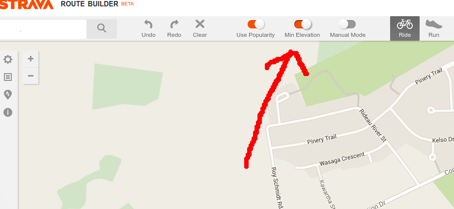
Yes, use strava map builder, and turn on the min elevation option:

enter image description here

The only bad thing about the app builder is the app itself is sluggish over time (something wrong with my browser?), but it's no a big deal, since you can always save a route and refresh the page.

Also, If I plan a long route, I've found strava heatmap is pretty useful , although popular routes don't always have the least elevation:

http://labs.strava.com/heatmap

1
  • I find Strava's route builder unusable on my tablet, but that's mainly an interface thing. I've not had any problems using it on Firefox on my Windows laptop over the last year-and-a-bit. So it's probably your browser if you're still having issues. Commented Mar 20, 2019 at 10:56
3

http://brouter.de/brouter-web/

Uses OpenStreetMap which is usually much better than Google Maps for Cycling. There are also 2 distinct bicycle profiles (fastbike and trekking) available and you can customize them.

4
  • Nice tool. Unfortunately it doesn't seem to be aware of the quality of bike paths (as are probably all the other available tools). Looks like nothing can match personal, local experience. Commented Mar 20, 2019 at 8:45
  • @cmaster: It does take surface (paved, unpaved, tracktype etc.) into account if that data is specified in the OpenStreetMap.
    – Michael
    Commented Mar 20, 2019 at 10:21
  • 1
    @cmaster: Agreed. However, I’ve traveled thousands of kilometers on routes generated by brouter and haven’t been disappointed yet. Of course I can’t know what I’ve missed ;) Without such a great tool I’d have to stick to the main roads which is certainly worse.
    – Michael
    Commented Mar 20, 2019 at 11:48
  • It is usually that local personal experiance beats BRouter and BRouter beats decisions over a map or other routing services. Particular criteria for the route choice are fully in hands of experienced users, see github.com/poutnikl/Brouter-profiles/wiki In terrain, LocusMap/Brouter combo is just great.
    – Poutnik
    Commented Aug 23, 2021 at 12:40
3

https://bikeroll.net shows you a nicely colored altitude profile where you can easily spot out the difficult part of the route.

1
  • That's a bit slow, but otherwise a very nice resource. Thank you for your contribution. Do consider browsing the tour to learn how SE works, and I look forward to your future contributions.
    – Criggie
    Commented Mar 15, 2017 at 0:26
3

For the BRouter-web frontend and BRouter Android application, there is also many script based custom routing profiles that calculate with SRTM based elevation of supposed routes.

The fully offline mode, together with LocusMap/OSMAnd/Oruxmaps applications, can be great advantage.

2

Yes. On Google maps you can plan a route. The Google earth picture will also give you almost a 3-dimensional view. If you use the Ctrl+C button and copy the link from Google maps of your profile (it looks like a chain in the box that appears to the left of the map). Then do a google search and type in 'GPS Visualizer'. It is (currently) a free program that will allow to paste in the profile under 'Draw a profile', and after pressing Ctrl+V, which copies the link details, and pressing 'draw the profile' hey presto, up comes your elevation profile of the route! This will allow you to see how hilly your route is, and compare other potential suitable routes and distances.

Your other option is to tackle those hills head-on, utilising a good hill climb technique, the right clothing, cleated shoes with pedals (without toe straps, known as clipless pedals), and gearing suited yo your needs, you can build your fitness over time and suddenly those hills ain't so large. The fun part/reward is going down, but that also requires the correct technique to be as safe as is possible.

However some steep and long hills will always be a mental and physical challenge, (especially if there are many of them in your route) no matter how fit you are. A cautious approach and tackling smaller hills is a good place to start, especially if your fitness is not high at present, or after a gruelling day at work, or at the end of a long ride when your energy reserves are about out. But over time you do improve.

Cycling shops should be able to advise or sell you a magazine or book on training tips.

After a 19 year layoff from cycling, 18 months ago I saw a Doctor for a general check up first, as I hadn't exercised in that time, but after quietly building up, and at first avoiding the bigger hills, Im now challenging those bigger, steeper and longer hills, even 30km long mountain climbs, and now going up them at a respectable rate. Although not as fast when I was 22 and racing competitively, as Im now 48, one has to be realistic in terms of time, priorities, money and energy availability. I guess from your comment about going a longer distance to avoid a hill, you have some basic fitness already. So I encourage you to build your overall fitness over time, and then give it a go!

I hope this answer helps, and isn't too long-winded. Regards and best wishes.

1
  • For as long as I can remember, Google maps has displayed the elevation profile when you tell it you want a bike (or walking) route, so there's no need to copy-paste to external software any more. Commented Mar 20, 2019 at 14:32

Your Answer

By clicking “Post Your Answer”, you agree to our terms of service and acknowledge you have read our privacy policy.

Not the answer you're looking for? Browse other questions tagged or ask your own question.