I commute to work on a single-speed road bike, so it's a lot easier if I avoid any steep hills (preferring to cover the same gradient gradually). Taking a look at a map, there are seemingly 3-4 sensible routes to get from point A to point B. Short of trying them all, is there any way to evaluate which has the most gradual climb?
-
1Strava has a "min-elevation" feature in their route planner. bicycles.stackexchange.com/questions/30583/…– TrevorCommented May 26, 2015 at 23:09
-
cyclingweekly.com/news/latest-news/… - a news feature that relates to this question directly. not sure if there's been any developments since.– Abdul-Kareem Abdul-RahmanCommented Jun 15, 2020 at 20:12
9 Answers
A lot of the online mapping websites have elevation data you can use to figure it out.
Example 1: Go to http://maps.google.com/ choose the bicycle icon and ask for directions. Once it gives you the map, switch to the "map" instead of satellite view and turn on the terrain overlay. When you ask for bicycle directions it tries to avoid steep climbs and the terrain data overlay can give you some idea how bad things are. You can drag points on the route to force it into giving you a specific route.
Example 2: Go to http://www.mapmyride.com/ -- go through the annoying interface to create a new ride (there's some annoying ad stuff). Once you've done that, you can see some data including a graph of the climbs. Do that for all the routes and compare side by side.
There's a lot of competing websites for that kind of thing that you can search for out there.
-
I didn't know about the google maps terrain view. It doesn't get quite as granular as I'd like, but it will show you the steep hills to avoid.– RyanCommented Apr 7, 2011 at 14:53
-
Also, if you find that Google Maps gives you a steep route and you know a better alternative, you can contact them and suggest it. I did this with a route near my house, and they corrected it to route by default along a gentler hill. See here: bicycles.stackexchange.com/questions/1644/… Commented Apr 10, 2011 at 20:37
That's 4 days to evaluate all the routes. I'd just ride them. You can spend a lot of time with mapping tools trying to evaluate gradients and still get it wrong. Unless you can find a cycling guide that discusses the issue you will almost certainly not get a good answer. For a motor transport engineer (the people who design roads) anything under 1:10 is fine on a minor road, 1:20 on a major road. They just don't care about short steep sections vs long gentle sections. The flattest route could easily be the one where you come out of a compulsory stop onto a short steep section that climbs less than the 5m interval between contours on a most-detailed map.
One electronic solution would be to use google streetview to survey each route. Look at the angle between the street and the vertical walls or horizontal floors. That will give you a rough idea of the slope of the road at each point.
-
The OP could at least use a ride mapping tool (Bicycling magazine has one in their "Training Log" section, and there are probably many others) to check for obvious bad spots.– alesplinCommented Apr 6, 2011 at 23:04
A very good solution is Google Earth. If you create a route (either create one or get a recorded track from a GPS device), you can see it's elevation profile (right click on the route and "Show Elevation Profile"):

The profiling is interactive and linked to the map, so you can easily see where the "problem" (eg too high elevation) is on the map and modify your track accordingly.
You might want to try bbbike.org, a cycle route planner based on OpenStreetMap data that I only discovered recently.
Other than standard Google routing (that in some countries doesn't provide detailed settings for cyclists), it allows to set precise preferences for the planning, for example only residential roads, or roads suitable for road bikes. After calculating the route, it returns the average run time, directions, a simple height profile, an interactive map and downloadable tracks in various formats that can be imported into Google Earth. From there you can follow Czechnology's answer.
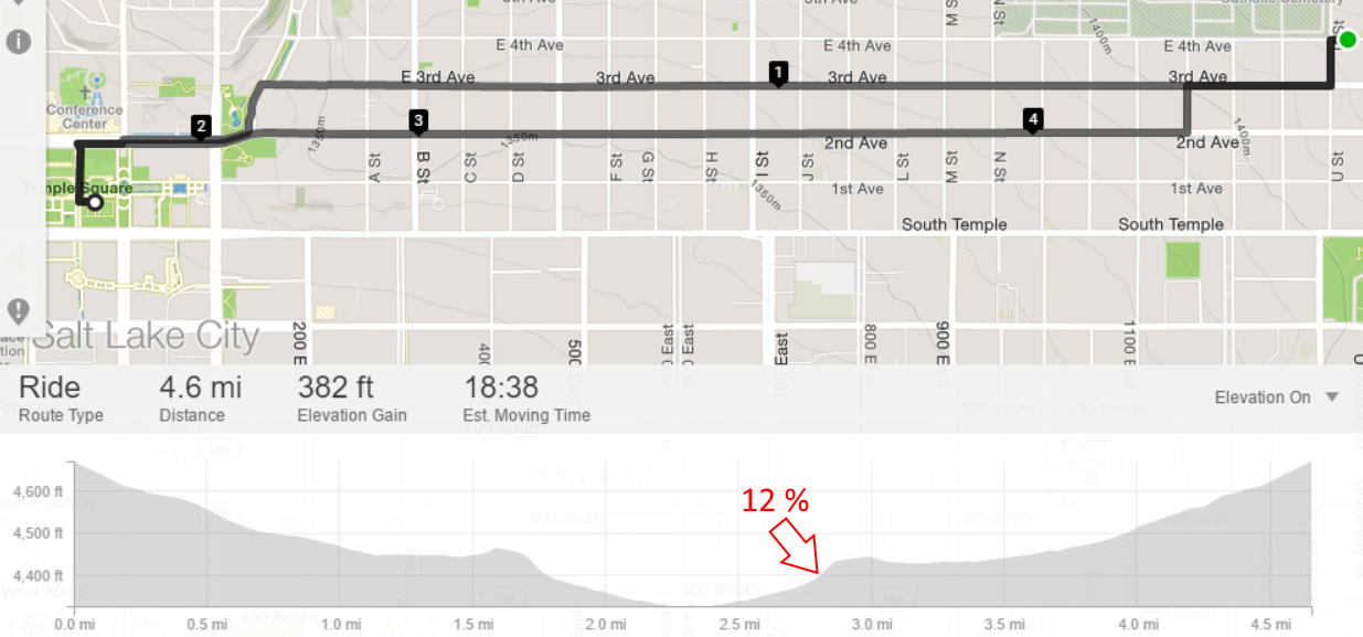
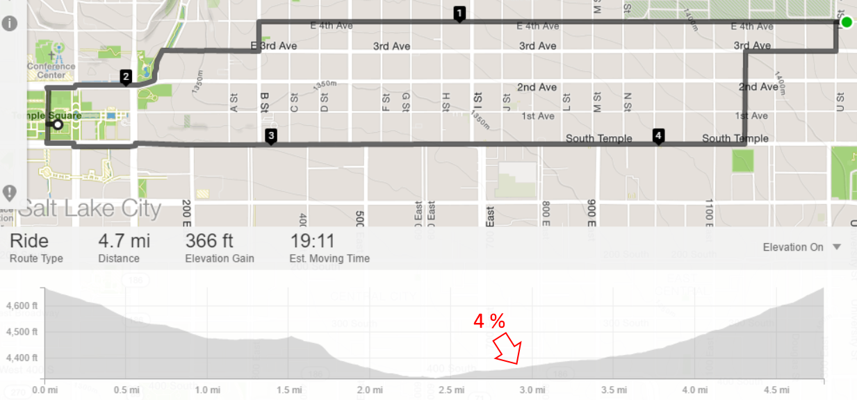
Strava has a fantastic route planning tool for both running and biking, including an option to minimize elevation gain. Their app is also great for tracking your activity, and integrates with many other tools.
For one of my routes, compare:

to this easier route without the climb:
Playing with waypoints can sometimes improve results - moving my endpoint over half a block can shift the routing to several of the east-west roads to get around a small hill.
Do you have access to an elevation map of the area? I believe on that type of map, the closer together the lines are, the steeper the grade.
-
The lines are called contour lines, and generally they're at least 10m in height apart. Which is not too useful for cycling.– МסžCommented Jun 15, 2011 at 23:26
You could try ridewithgps. It's fairly simple. You go to this site and plot out a route(s) on the map. As you create the route you'll get a graphic of the elevation profile below the map.
Try this it is the best I have seen.http://www.bikeroutetoaster.com/. Neil: yes of course. The website allows you to actually map the route and works out the road stuff for you so you can just work out the main points rather than every time it changes direction. Also it does all the height stuff and a text print out. Remember in the UK we do not have bike on google maps.
-
1welcome to Bicycles. Answers that are just a link are generally unhelpful. Can you explain why you like this site and what's good about it? Commented Apr 8, 2011 at 13:36
-
If you want the best of all of these just put your route on mycycletour.com. It will give you the elevation profile, and also run a streetview movie of the journey so you can see how steep the hills are.

