16

I've got a Garmin Edge 810. Sometimes when using routes created with Garmin Connect or Strava Route Builder, I unfortunately find myself on bad gravel roads.

Is there a route planning tool that allows you to only select asphalt/tarmac?

2
  • 1
    I have the same problem, I've been caught out a couple of times and it always happens (pretty much by definition) on unfamiliar roads. I don't think there is any kind of magic tool/setting, but I have got into the habit of viewing my route in "aerial photography" mode although even that isn't foolproof.
    – PeteH
    Commented Apr 23, 2014 at 13:13
  • 2
    I'm not aware of a tool that does exactly what you want (hence the comment instead of an answer) but open.mapquest.com/ will at least give you a way of checking the surface. It's based on openstreetmap and most openstreetmap contributors fill in the surface field when uploading a path/road. It allows drag-and-drop manual route planning like google does, and has an elevation option (that's not working for me at the moment).
    – Chris H
    Commented Apr 23, 2014 at 14:24

3 Answers 3

11

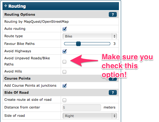
Use Bike Route Toaster and make sure you are using Open Street Maps Cycling version ("Open Cycle Map). As part of the route finding options under Open Street Maps there is an "Avoid unpaved roads/paths"
enter image description here

I have successfully used Bike Route Toaster with a Garmin 800 in the past. I planned out a 1000 km journey across Norway on back roads, gravel (eek!) and paths. It was amazing how well it worked, thanks to the all the hard effort of volunteers around the world who contribute to the cycling version of open street maps. I only had one minor hiccup in all those miles.

Good luck!

2
  • I got "The connection has timed out" for bikeroutetoaster.com when I tried it. Commented Mar 2, 2019 at 21:45
  • 1
    @PeterMortensen yeah, the service seems to have recently become defunct.
    – Rider_X
    Commented Mar 2, 2019 at 21:46
2

I am planning to bike across Pennsylvania this summer and I am having trouble finding good roads to use for biking. Then I hit upon the idea of Google street view (and the Microsoft version of it). Using street view has been a fantastic help for me! I have found a route that has paved shoulders for my entire north/south route! And that was in a couple hours. My plan is to spend more time looking for alternate routes over the next week or two.

2
  • I have the opposite problem. I want to ride gravel and dirt roads. I use ridewithgps and with google satellite view and street view to help identify the roads. Though, the resolution suffers in more rural areas and dirt/gravel roads are less likely to be on street view.
    – Benzo
    Commented Apr 29, 2014 at 22:37
  • 1
    @Benzo: Have you tried topographic maps? I just planned a hiking tour yesterday with Garmin's Topo Deutschland and Basecamp and different types of pathes are easy to discern.
    – arne
    Commented Apr 30, 2014 at 7:09
0

I tend to find that in the UK at least, a quick check if the road has been 'Google StreetViewed' will show if it is tarmac or not. You can quickly check this by dragging the 'pegman' (little orange StreetView icon located above the zoom bar), if the road has been StreetViewed then it will turn blue.

In my experience over 90% of coloured roads on OS Maps (i.e. not white) are paved, these can be seen on http://maps.bing.com.

6
  • OS maps don't really: "Other road drive or track" (parallel lines which may be solid or broken for fence or unfenced, white in between possibly with a right of way) can be paved or unpaved. These may be farm tracks with bridle ways running on them for example. While the vast majority of UK roads are paved there are a few exceptions, which are not shown any differently on the OS maps.
    – Chris H
    Commented May 2, 2014 at 10:29
  • coloured roads are nearly always paved.
    – mjsqu
    Commented May 2, 2014 at 10:49
  • "nearly" always - my point exactly. I've come across a few unpaved that look would like perfect alternatives to main roads on the map. I think they've paved the one near Exminster that nicely links to a canal-side cycle path, but that caught me out a few years ago, yellow on the map.
    – Chris H
    Commented May 2, 2014 at 10:53
  • The pegman thing is still valid, was it worth a downvote? I'll remove or caveat my erroneous OS statements...
    – mjsqu
    Commented May 2, 2014 at 11:02
  • 1
    I've changed the OS bit and supplemented Geoff's answer with the 'drag' functionality that highlights roads in blue.
    – mjsqu
    Commented May 2, 2014 at 11:07

Your Answer

By clicking “Post Your Answer”, you agree to our terms of service and acknowledge you have read our privacy policy.

Not the answer you're looking for? Browse other questions tagged or ask your own question.